Today was an extra special day, as it is Sheila's birthday! She turned 9 years-old, and while that's considered a senior dog, she is very much still our fur baby, with oodles of energy to hike and explore with us each day. In another 3 days, it'll be Sheila's 6 year adoption anniversary with us. She's certainly had a ton of adventures over the years, and this year is undeniably action-packed so far!

We had parked our RV next to what seemed like a bit of a trail, and Lisette walked Sheila in the morning, feeling cautious as they rounded a corner in case there was a large animal of some sort they'd encounter. There weren't any animals, but there were plenty of signs they'd been in the area, with poop around the trail. While the weather wasn't exactly warm, it was a beautiful and sunny day, so we had our breakfast sitting outside, enjoying the serene view.
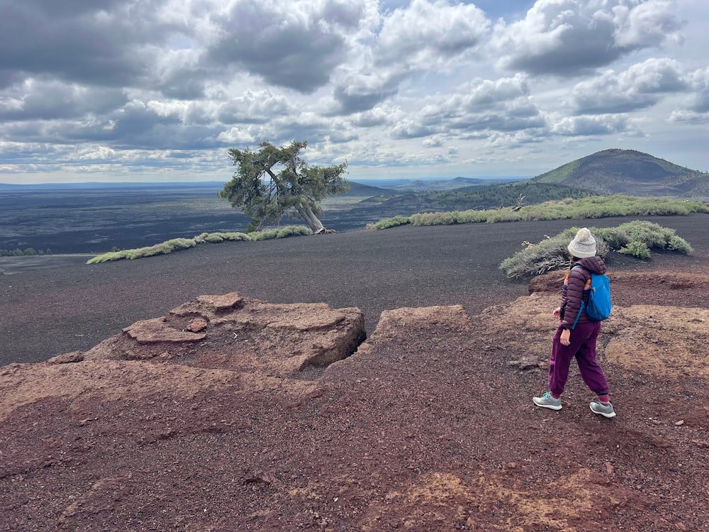
If you've every dreamed of walking on the moon, Craters of the Moon National Monument and Preserve is the closest thing on Earth to doing it. The landscape is broody, blackened and rugged, with lava fields, cinder cones, and formidable caves, formed from ancient volcanic eruptions. The terrain is actually so similar to the moon that NASA astronauts trained here before blast off!
The Trails at Craters of the Moon
At the Visitor Center we found out that the caves were currently closed, so unfortunately we couldn't check these out. A free permit is required to enter the caves, to protect the bats. We also needed to protect Sheila's paws, staying on paved trails for her as the rugged, gravelly terrain would shred her paws if she walked on it!


So our itinerary involved driving the distances from one short trail to another. Our first trail was the North Crater Flow Trail, a short (0.48 km/0.3 mi) paved loop trail, on a boardwalk to check out some of the youngest lava. Just like Inuit have different words for the types of snow, there are different words to describe the lava that come from Hawaiian: "pahoehoe" refers to a type of basalt lava flow that has a smooth surface, while "aa" is has a rough, jagged surface. Even though the landscape is so dark and foreboding, the soil is surprisingly fertile, with wildflowers growing among the lava. Next to this boardwalk there's stairs leading to the top of a hill which gave us a view of our surroundings, but because it wasn't paved Sheila had to stay inside for this one!
The Devils Orchard Nature Trail is also short (0.8 km/0.5 mi), and is a paved loop through a sea of cinders and scattered islands of lava. It was rather cold and windy, and the leafless trees looked almost creepy with their gnarled branches outstretched towards the sky.

A short drive after this is the Inferno Cone, which is again a short walk (0.3 km/0.2 mi), but is up a steep hill, making it a lot more strenuous! It's unpaved so Sheila had to sit this one out, but we hiked up the cone, gravelly rock crunching under our shoes, and got to see 360-degree views of the Big Cinder Butte and the Great Rift. There were actually trees on top of Inferno Cone! It was starting to get icy cold, so we jogged down the steep hill to get back to the RV. As we were making our descent, we noticed that the lava rocks were not just pure black, but also had beautiful tints of blue as well. The rocks look heavy, but they are extremely lightweight no matter what size, which makes sense because they're like pumice stones.


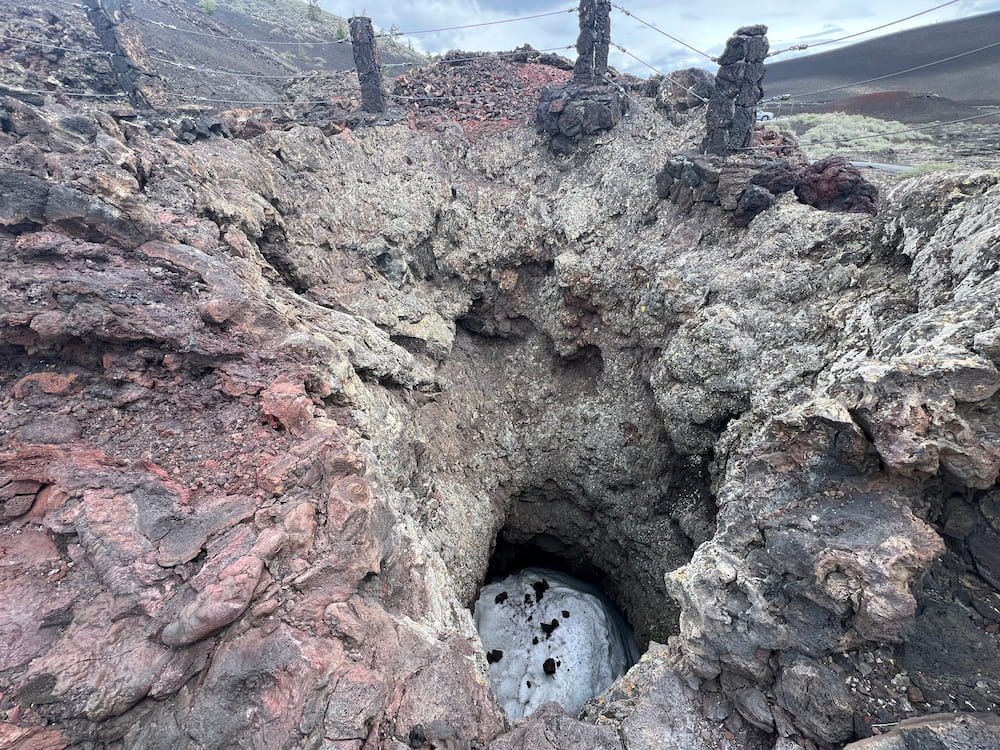
Finally, our last stop was the Spatter Cones and Snow Cone, where we took a short stroll to peer down at these miniature volcanoes! It was super cool to see the different colors inside the Spatter Cone--the reds popped out more against the grey and black volcanic rock. And true to its name, there was snow in the snow cone!

We considered doing one of the longer hikes, such as the Broken Top Loop Trail, a 2.9 km (1.8 mi) round trip where you can see nearly every type of volcanic feature characteristic of Craters of the Moon, but no sooner had we finished the other walks that it started to rain, and rain heavily.
Shoshone Ice Caves
Shoshone Ice Caves (pronounced Sho-shone) is a large lava ice cave, which is about 518 meters (1,700 feet) long, 15 meters (50 feet) wide and 13 meters (45 feet) tall. To go into the cave, there's a guided tour that costs $15 per adult, taking us 30 meters (100 feet) underground to learn about the caves and see them up close. The tours operate from May to September.


The cave is now owned by a family who purchased it in 2019, and we took the tour with the son, who had turned 16 that week, and has spent many summers living near the caves and showing visitors around. We were fortunate to be the only people doing the tour, so we were able to take our time to walk down into the cave (which is well-lit, no need for flashlights), and see how the cave was once a source of ice for refrigeration from the 1800s until the 1940s. At one point, people used to even ice skate inside it! At one point the lights were turned off so we could see some minerals that glowed in the dark, which was cool (no pun intended) because they were all different colors.


Besides the Ice Caves, there's a gift shop, a museum with the history of the cave along with a rock and artifact museum, and a couple of statues: a 9 meter (30 foot) tall statue of Chief Washakie, a noted chief of the Shoshone Tribe, as well as a gigantic green dinosaur, Dino, with a person riding on top of it.
Perrine Memorial Bridge and Snake Canyon River
We passed by a couple of small towns, although it was a tragic to see that there were many flowers on the side of the road, marking spots where people had died from car accidents. We also passed a ton of cows packed into pens rather than being allowed to roam free. It clearly makes a huge difference, because the smell is terrible driving past the hundreds of cows that can't move around much, and are destined for the abattoir... Lisette doesn't eat meat, so this reaffirmed her decision!

Twin Falls is a much bigger town and has the Perrine Memorial Bridge, which looks over Snake Canyon River. There was a Visitor Center on the south side where we parked that was pumping out classic pop hits (Michael Jackson, anyone?) across the canyon, with a ton of volunteers preparing for a 5k fun run for the following day. Alongside the canyon there's a path where we could see a bunch of fancy houses in the distance, with sweeping view s of the river as well as an immaculate and likely expensive golf course.

What's unique about the Bridge is that it's also one of the few bridges where BASE jumping can be done without a permit, and is allowed all year round. It's about 148 meters (486 feet) to jump down, and while we didn't see anyone jumping when we were there, it'd certainly be quite the adrenaline rush!

Speaking of which, Evel Knievel attempted to jump over Snake Canyon on a motorcycle, and there's a plaque about detailing his most daring and final jump in 1974, which failed because the parachute opened on takeoff. We had to leave the Visitor Center and drive to the other side of the canyon to see the dirt ramp that he used for this attempt. To get here, we drove through some new housing developments, and parked next to a field with cows--and marmots! This was our first time to see them up close, and they make a very unexpected high-pitched chirping sound! Fortunately Sheila was in the RV, or she would have gone ballistic seeing them and tried to chase them all down.
As we were leaving, we had another first: Lisette driving the RV! It was probably no more than a minute (and it probably took more time for Michael to tell Lisette how to start it), but she was able to give it a go in a open space. The marmots, cows, and any other animals were all far away, at a safe distance!


Shoshone Falls & Twin Falls
The Shoshone Falls are often referred to as the "Niagara of the West", standing at about 64 meters (212 feet) tall, 45 feet higher than Niagara Falls. It costs $5 to drive in to se the falls from March to September. There's a lovely park to picnic, hang around, or if you were like the kids we saw, lie horizontally at the top of the hill and roll down to the bottom!!

Sheila walked around the paths with us to scope out Shoshone Falls, and was fawned over by a couple who we chatted to briefly, who were there with their son who had just graduated (and was in his graduation clothes). As soon as we got back to the RV, Sheila suddenly decided to beat Lisette to her seat, and sat in the passenger side until our next stop! She hasn't sat in the passenger side since the very start of our trip so it was surprising to us that she did this, but we laughed and let her enjoy the view, as today is her 6-year adoption anniversary with us!

A little further away we also checked out Twin Falls, which has a power plant, a small park and picnic area. It's free to come here, but despite its name, it's a single waterfall only.
Marmots and Canada Geese
We'd read that the town of Twin Falls is not great for RV overnight parking, and it's not uncommon for a sheriff to knock on your door or windscreen to tell you to move on. We found a spot to park in the nearby town of Hagerman, at rest area in a park. For her evening walk in the area, Sheila saw marmots (which Lisette recognized thanks to their high-pitched squeal), which only made our dog more excited, seeing them nearby perched on rocks. There were also a gaggle of Canada geese, squawking and wandering around. Nature sounds are much, much better though to sleep to than those of the city!
Route Map