After 4 action-packed days at Arches National Park and around Moab, we treated ourselves to a relatively late start, leaving our campsite well after everyone else had driven off. Our plan was to further immerse ourselves in nature, heading to Dead Horse Point State Park.
Dead Horse Point State Park
The Park’s morbid name comes from a legend about cowboys who used the area's unique geography to corral wild mustangs. They would herd the horses across the narrow neck onto the point and block the passage with branches and brush, creating a natural enclosure. One day,a group of horses was left confined on the plateau, dying of thirst within sight of the Colorado River below.

Perched 609 meters (2,000 feet) above the Colorado River, Dead Horse Point State Park provides a truly breathtaking panorama, with massive red rock cliffs, winding river bends, and high desert vistas that make it easy to see why it’s so popular and extensively photographed. We made the most of our day by walking along the rim to take in all the scenery. We started on the East Rim Loop, stopping at the Shafer and Meander overlooks before circling back along the West Rim Loop, to see the vistas from all angles.

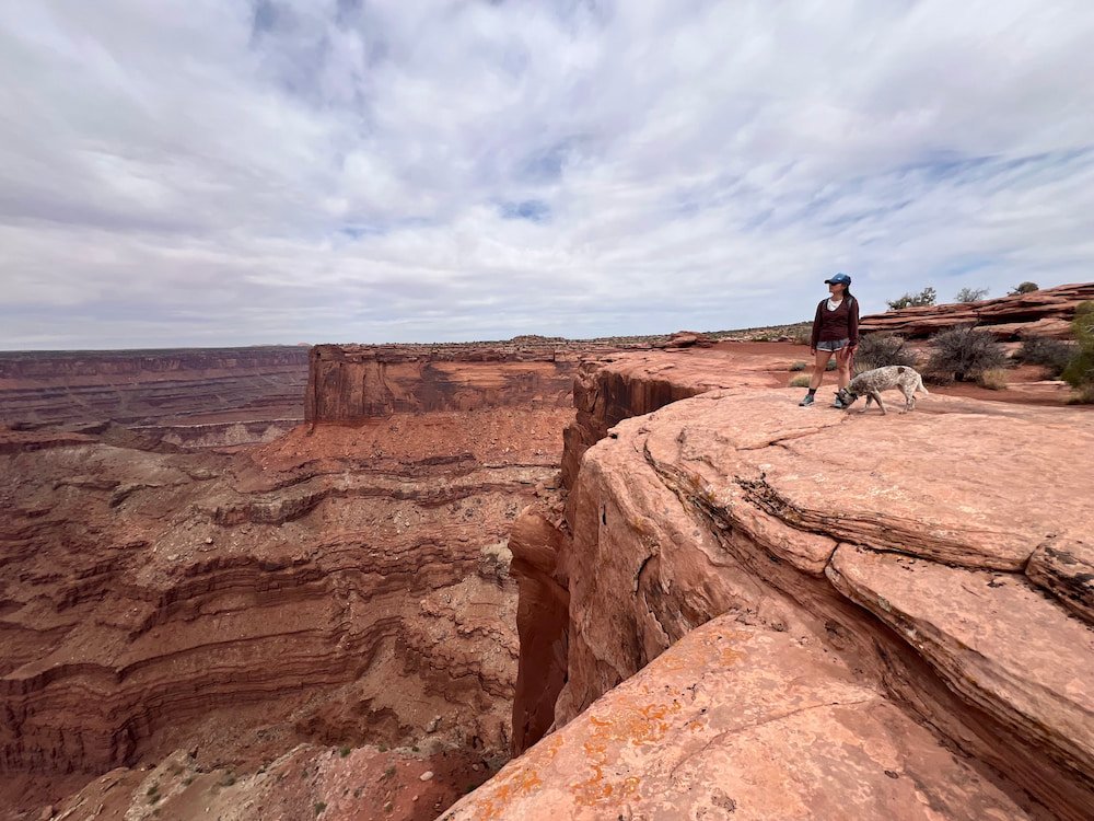

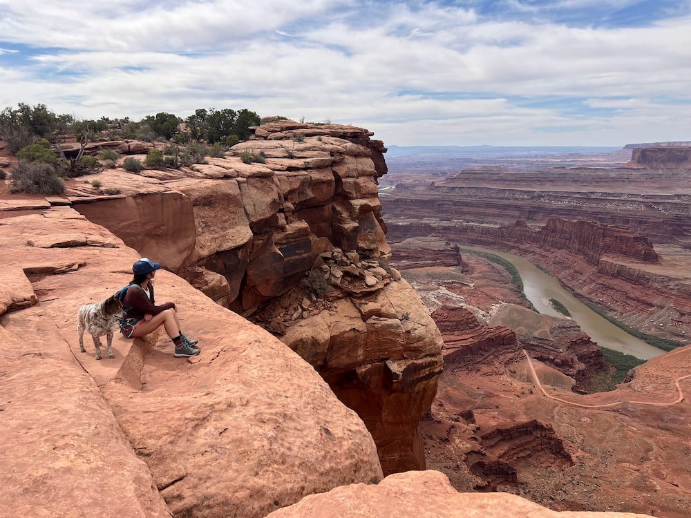
Despite it being a highly photographed Park, we often found that we had a lot of the scenic overlooks to ourselves – it seems that not many people chose to hike who visited (or at least didn’t do hike as much as we did), and it was definitely less crowded compared to other sights in the vicinity. We were a bit surprised to find that we could walk precariously close to the edge, which definitely makes for some awesome photos, although we didn’t get too close to be uncomfortable! Words cannot describe the otherworldly sights that we saw as we peered over the edge, but hopefully the photos give a sense of the grandeur in front of us. Sheila also had fun walking along, and meeting a crow who we tried to entice to have some of Sheila’s unwanted water from her bowl (the crow was very curious about us, but not interested enough in drinking from Sheila’s portable silicon vessel).


As we returned to our RV, the wind became increasingly stronger, so we rushed back to have lunch. As we were inside, the wind continued to pick up, as evidenced by the vehicles around us steadily dwindling in number as they left the park. We figured we’d leave soon too, but our eyelids started to get heavy after our meal, and we unwittingly had an afternoon nap while the gusts blew around us. Traveling can be an exhausting affair!
Canyonlands National Park
Fortunately our next stop, Canyonlands National Park, was not far away, and we arrived late in the afternoon to orient ourselves to the massive park. It’s one park, but there are four districts: Island in the Sky, The Needles, The Maze, and The Rivers. Island in the Sky is closest to Moab, and the most visited district. The Needles is a farther drive, and is popular for backpacking and backcountry hiking. The Maze is the most remote and rugged district, requiring a four wheel-drive, high-clearance vehicle (so we would have to skip this), and is recommended for more experienced hikers to explore – but it also has sacred sites from Indigenous cultures, making it a unique trek. Finally, The Rivers separate the other three districts with boating activities.

Island in the Sky: Awesome Overlooks
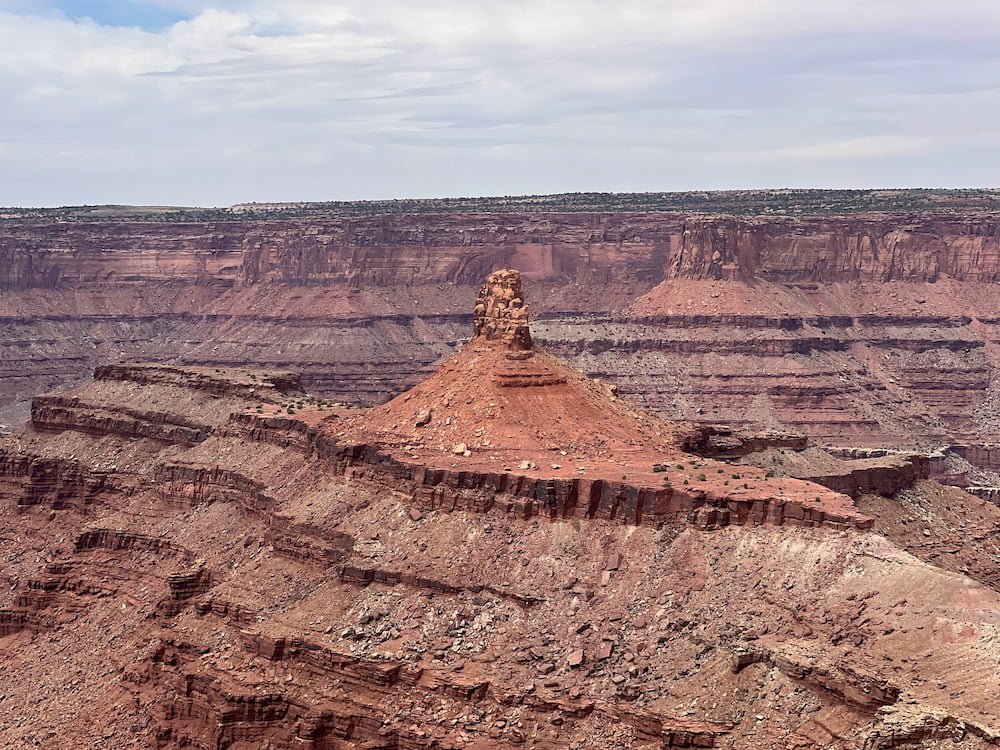
Our entry point started at Island in the Sky, a mesa perched atop sheer sandstone cliffs that rise over 300 meters (1,000 feet) above the surrounding landscape. There are lots of overlooks where you can simply park, get out of the car and take in the spectacular views all around you. There’s limited camping options that are first-come-first-served (only 12 sites with no water or hookups), so we went there first but found that all the spots were taken.


While there are some hikes at Island in the Sky, it seems to us to be a place that’s best absorbed by stopping at the various overlooks, and look down at the incredible buttes, canyons, rock formations and windy roads below, which criss-crossed around each other to make a beautiful tapestry of a landscape. It’s a straightforward drive to stop at the various overlooks. We started at the furthest one from the visitor center – Grand View Point Overlook, before snaking our way up through 4 others: Orange Cliffs Overlook, Buck Canyon Overlook, Candlestick Tower Overlook, and Green River Overlook. All of them have something special to offer, so we felt it was worth checking them all out!

Grand View Point Overlook, like its name suggests, is the most sizable in terms of how many people can park and look over the edge, getting a panoramic view of the terrain below, as far as the eye can see. We could see the Green River and Colorado River intertwine into each other, and The Needles district with winding roads leading down to it. The other overlooks were all incredible and varied in the different aspects, and since they’re all easy to get to once you park your car and not too far from each other, it’s worth stopping at each to compare and contrast the views.
Mesa Arch
We then continued on to Mesa Arch – you can’t see the arch that well from the carpark, but it’s a short walk away, but once we got there we loved walking right up to the arch, where you can sit underneath it and look through to the views below. There’s also a few rocks and short paths to scramble around the arch, making for a fun area to spend time in.


Shafer Canyon Overlook
One of our favorite and surprising spots to check out was right near the Visitor Center, at the Shafer Canyon Overlook. Since this was the last overlook before we headed out of Canyonlands, we thought we’d seen it all at this little spot – but we were blown away once we got to the edge and saw the stunning view of Shafer Trail, a road that zigzagged at sharp hairpin angles below us. The distance from the road below really gave us even more of a perspective of the distance and sheer drop below, and it made us feel small compared to the magnitude of the terrain below us! Looking straight down when there’s no fence or barrier to the road below may also not be for the fainthearted!

We left Canyonlands the same way we came, as The Needles is quite some distance away from Island in the Sky, entering at another entrance to the southeast. Since we were looping downward, we passed Moab and ordered Thai food, our second time to have Thai cuisine so far on this trip. Michael could eat Thai food everyday, so he definitely misses it! His go-to dish (chicken pad kaprow, or Thai holy basil stir fry with chicken), passed Michael’s taste bud test, although the chef’s special that Lisette ordered of drunken noodles was not a hit (vegetable to noodle ratio needed way more vegetables).
We were able to find a quiet spot on the side of the road just outside the sign for The Needles, ready to start our day there tomorrow.
Newspaper Rock Petroglyphs
In the morning, we drove past the sign to The Needles. Before arriving at the Visitor Center, we checked out the Newspaper Rock Petroglyphs, which is on the way. Newspaper Rock Archaeological Site is a petroglyph panel from around 1300 AD. Prehistoric peoples, probably from the Archaic, Basketmaker, Fremont, and Pueblo cultures, etched into the sandstone, with Ute, Navajo and European Americans adding to the panel many years later. There are a lot of different petroglyphs to see, including what looks like bats, bighorn sheep, wheels, and even demon-like figures, and it’s up to everyone’s interpretation as to what these symbols all mean, as the stories behind these have all been lost in time.

The Needles: Happy to be Hiking
We arrived in The Needles, which is great for hiking and exploring compared to the short walks and vista overlooks that define Island in the Sky. There are also a lot of areas that can be explored on four wheel-drive vehicles, and others where a permit is required for entry, which we had to miss as our beloved RV would be pushed well beyond its limit.
The Visitor Center was a great initial stop, as it includes a few exhibitions on how the magnificent terrain and rock formations have come to be, plus a very important reminder to stay on the trail so that you don’t damage the fragile ecosystem, which can take years to recover from a simple footstep, or even never!!

We decided to hike the Slickrock Trail first, which is a 3.9 km (2.4 mile) loop. There are plenty of rock cairns along the way to ensure that you don’t get lost, and the rock was very sturdy for us to walk along and take in the beautiful nature around us, including a few points where we could experience some incredible views. It’s not particularly shady, so the hot sun was beating on us as we made our way back to the RV.

At Pothole Point, we strolled through this short loop (1 km/0.6 mile) trail that is indented with pockets called potholes, like what you’d imagine on the surface of the moon. The potholes are tiny in parts and can be highly sensitive, with sunscreen, body oils and soaps easily polluting the water dwelling in these potholes, so it’s advised to walk around them.
Cave Spring Trail
One of our favorite trails to explore at The Needles was the Cave Spring Trail, a short (1 km/0.6 mile) but eventful loop that includes a historic cowboy camp (complete with furniture and other artifacts tucked within a cave), prehistoric rock markings, and various signposts for the flora dotting the trail, such as four-wing saltbush, greasewood, and other plants. It was really interesting to learn about these desert plants, what they look like, and what their uses have been over the years. Back in Arizona, Lisette had purchased a greasewood salve to soothe her dry skin (thanks to the desert climate), and it was fun to see the actual plant, with its short, upright spikes! On the Cave Spring Trail there’s also two ladders that scale up to the top of the rock, where you can see more great views around you.


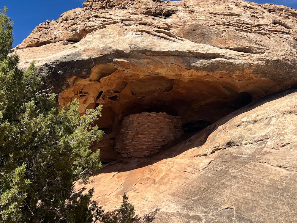
Stone Storehouse
Our final stop was the Stone Storehouse, a short 0.5 km (0.3 mile) trail that passes a small structure tucked beneath a ledge. Nearly 700 years ago, Indigenous people built small stone structures, likely for ceremonial or storage purposes, suggesting that farming took place in this area. It’s fascinating to imagine how resourceful and ingenious people were back in those days, without a handbook to figure out how to best live off the land.
As the daylight tapered off, we drove to the town of Cortez, stocking up on groceries since we expect to be immersed in nature for the coming days. That evening, we scaled a winding mountain road, arriving at Boggy Draw Trails, a popular mountain biking area, for a peaceful night tucked within the forest trees, away from any light pollution.
Route Map
